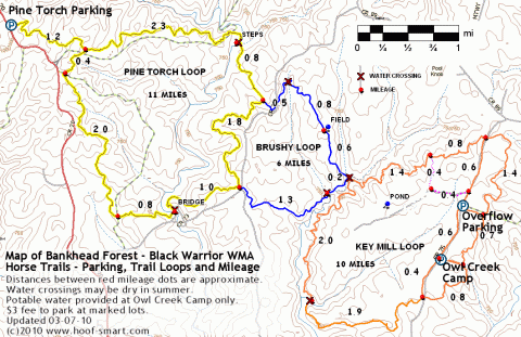
This map of the horse trails in Bankhead National Forest, Lawrence County, Alabama, shows the three main trail loops, roads, parking areas, trail mileages, and water sources.
Follow the directions below to make your own pocket (or saddlebag) size waterproof map of the designated horse trails at Bankhead National Forest.
- Print the pdf document linked below.
- Fold in half crosswise and lengthwise, with both maps facing the outside.
- Seal the folded map in a sandwich-size plastic zipper bag
- Stow the map in a pocket or saddlebag
- Hit the trail!
Print this pocket-sized, double-sided mini map of Bankhead Forest horse trails.
The trails marked on the maps linked above are designated horse trails, located in the Black Warrior Wildlife Management Area, Bankhead National Forest, Lawrence County, Alabama. Â
Need driving directions? Campsite information? A detailed weatherproof map of the horse, hiking, and ATV trails in Bankhead National Forest is available from many North Alabama area outdoors stores. Trail maps are also available at the outfitter store located in Wren, AL at the intersection of Hwy 36 and Hwy 33 just outside the Forest to the north. You may also write, call, or visit the US Forest Service Ranger Station in Double Springs to obtain maps or other information about visiting the Forest.
USFS Ranger Station
1070 Highway 33
Double Springs, Alabama 35553
256-489-5111
Tags: trail riding
-
Pingback from HOOFsmart · North Alabama Horse Trails on the Web on 05/12/2010 at 4:38 pm
Comments are now closed.

2 comments